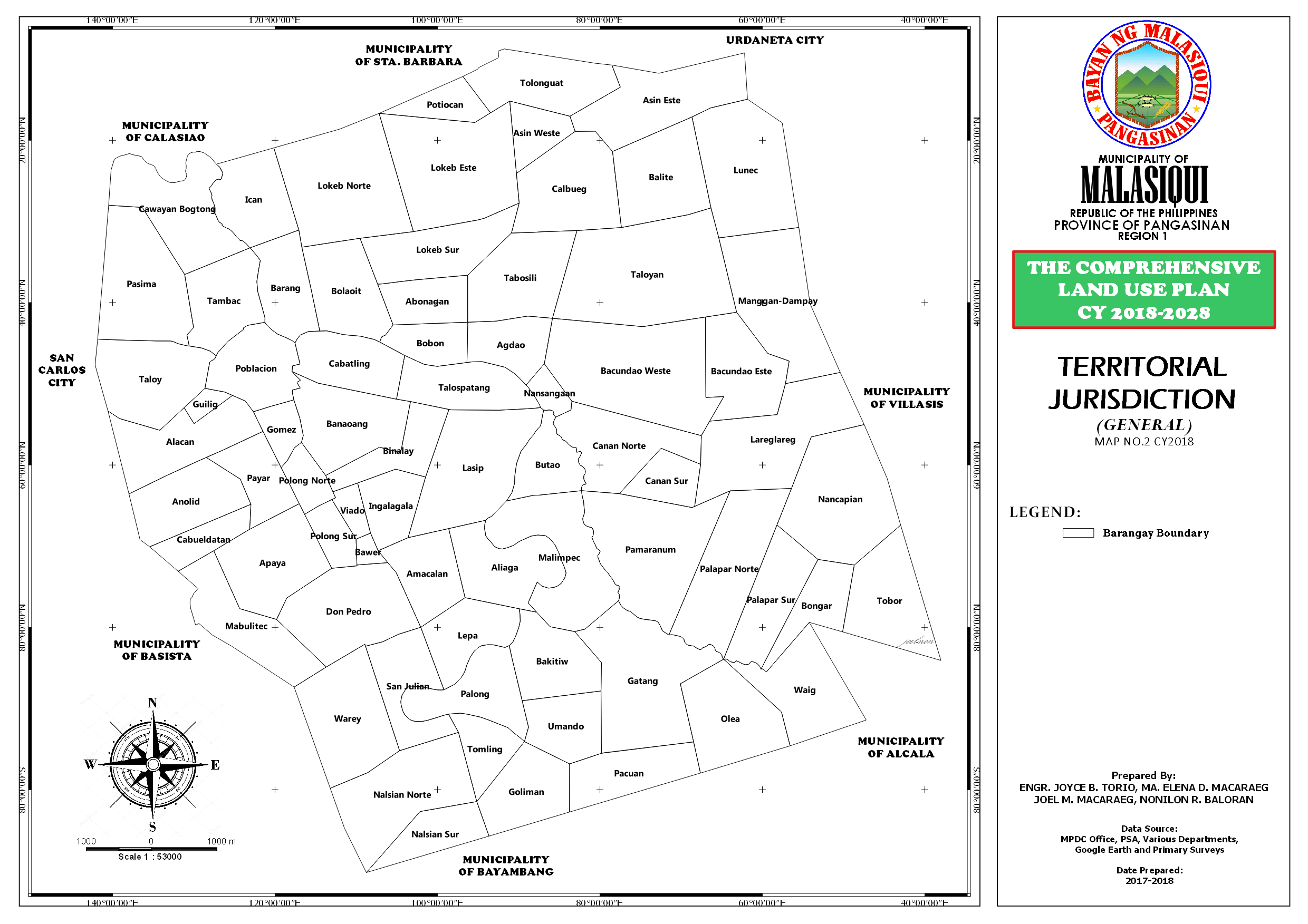
Based on the cadastral survey of the Municipality of Malasiqui undertaken and duly approved by the Lands Management Bureau of the Department of Environment and Natural Resources. The total land area of Malasiqui is thirteen thousand one hundred thirty eight (13,138) hectares. Malasiqui is the 16th largest municipality in the Province of Pangasinan and one of the two biggest in Central Pangasinan. Malasiqui has seventy three (73) barangays classified as urban and rural. Poblacion an Urban barangay, has the biggest land area of 907.8 hectares, the next 9th biggest barangays are Calbueg with 508.66 hectares; Lokeb-East of 470.24 hectares. Bongar has 433.56 hectares; Asin east is 321.15 hectares; Abonagan with 317.05 hectares; Lunec has 286.9 hectares; Barangay Taloyan has 282.87 hectares; Don Pedro with 301.88 hectares and Ingala-gala has 277.07 hectares. The smallest barangays are Bawer with 11.24 hectares.
Silt Loam soils generally contain high levels of silt with some measure of sand and clay. Heavily silt soils will benefit from amendments to improve drainage aeration and overall soil. structure. Silt particles are very small and can compact easily. Compacted soils drain poorly and do not allow optimum root to seep. Silt Loam soils will benefit from composted manure, composted vegetable matter, ground and aged pine bark or a commercial soil conditioner. Most agricultural extension services recommend applying a 2-to-4 inch layer of organic material and working it in to a depth of 8 to 12 inches as this is the root zone for most garden plants Silty loam soils are the most balanced and support the greatest diversity of plant life. Plants that grow well in silty loam, but the species that particularly like loose, fertile soil do especially well-grasses, bamboo, wetland and aquatic plants, vegetables, fruit tree, berry bushes and ferns.
There are four (4) types of soil in the Municipality of Malasiqui. The San Manuel Silt Loam has the largest coverage 1t 83%; Tarlac Clay Loam is 9%; San Fabian Clay Loam is 7% and 1% for San Manuel Fine Sandy Loam. Soils are broadly classified according to the types of particles present, such as clay, silt ,sand and loam are the four major particle types, each conferring a specific set of properties. Most soils are aggregates that contain different percentages of each particle type. The Municipality of Malasiqui has four type of soil as follows:
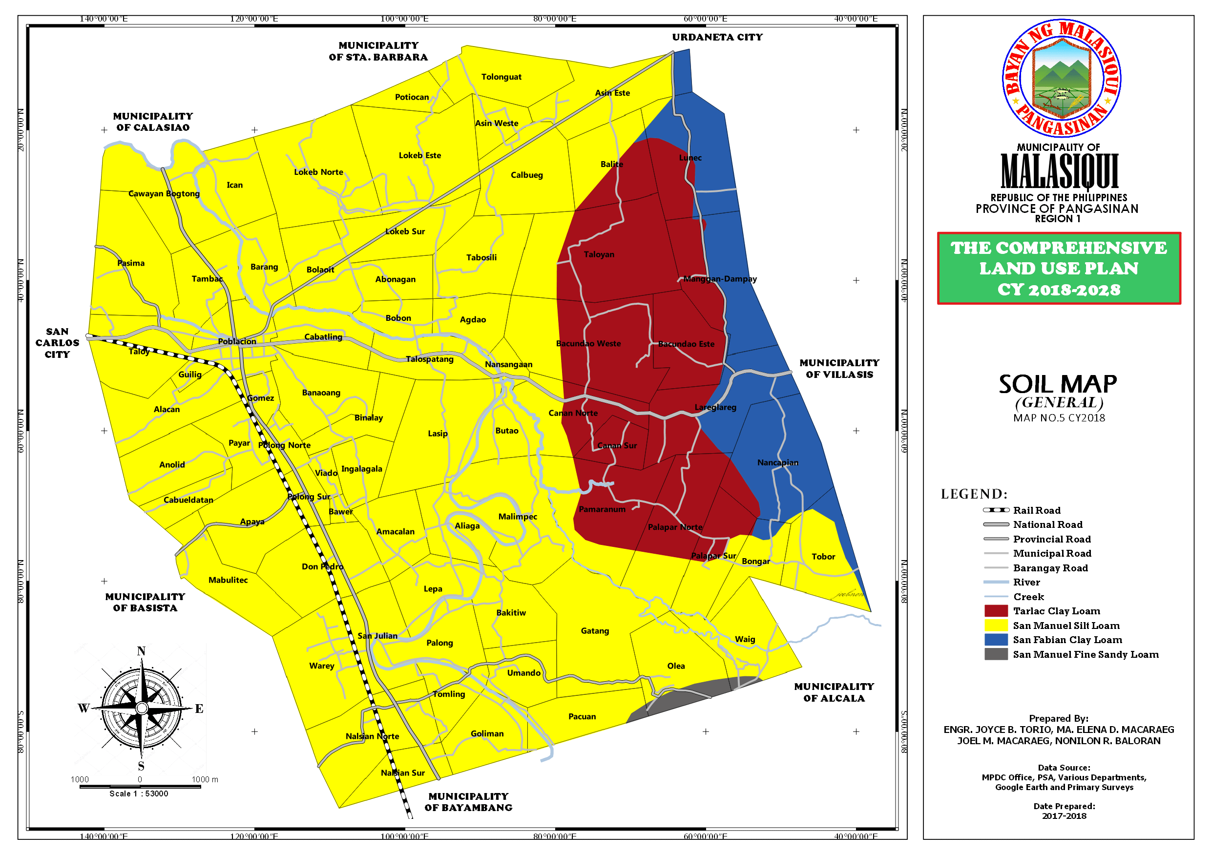
local_policeSan Manuel Silt Loam
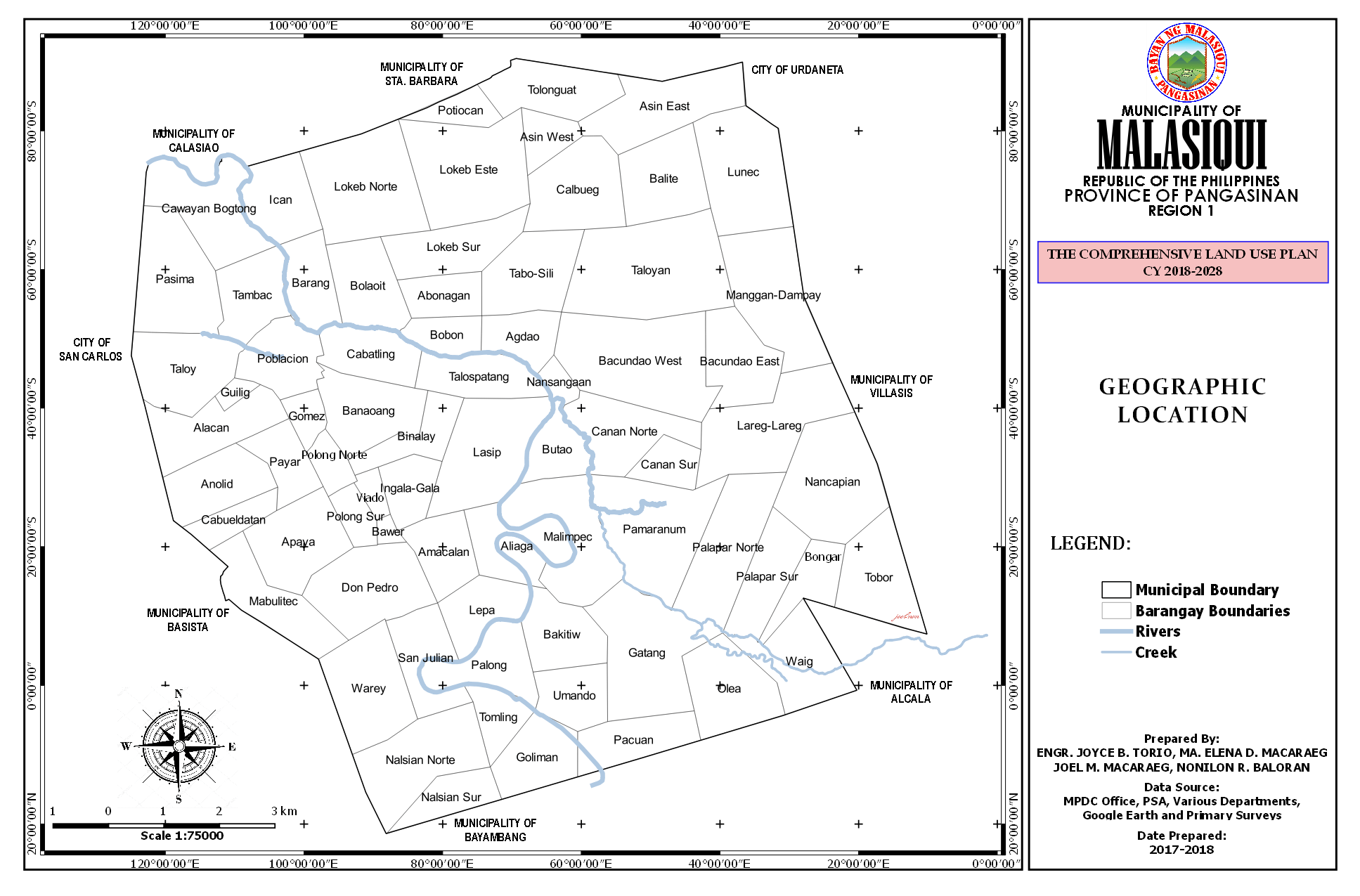
Topography is a detailed map of the surface features of land. It includes the mountains, hills creeks man-made features. It shows the specific relations of component parts as to shape, size, system or part of the body showing specifics relationship. The Municipality of Malasiqui is characterized by a flat land range topography consisting of plains on the north, west and central areas; rolling upland on the eastern part and lowland on the south-eastern tip near the Agno River. From the total land area of 13,138 hectares, 2,936.63 hectares are sloping to moderately rolling areas while 76% of 9,907 hectares are level lands and the remaining 1% is gently sloping undulating land. There are also marshy areas in Barangay Mabulitec, Apaya, Don Pedro and Warey.
On its south-eastern tip is the Agno River approximately 1.12 kilometers from the southern boundary of the Municipality. The Ingalera River is the major River tributary in the locality traverses various barangays on the western part of the municipality, together with these are various creeks also utilized to supply water into the irrigation canal in the rural barangays to irrigate the arable lands in the municipality. Approximately 32.91 hectares occupied by the bodies of water.
The general land use classification of the Municipality of Malasiqui by the Department of Environment and Natural Resources (DENR) are 100 percent of the total land area is Alienable and Disposable Land. It has a total land area of 13, 138 hectares. Bodies of water represent 0.25 percent of the total land area of the Municipality.